

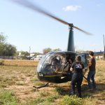
Aerial Surveys Provide Animal Population Data Quickly
Aerial deer surveys are effectively utilized to obtain buck to doe ratio, fawn production, antler development and more.
“An aerial survey provides necessary population data in a short time frame. This information can be utilized to provide harvest recommendations for the entire ranch as well as individual pastures.” –Texas Parks and Wildlife
Flown in transect lines, helicopter deer surveys are taken at a 50 ft. elevation through GPS coordination to ensure full coverage of your property during survey. The Season for Wildlife Surveys runs from September 1st- March 30th
For more information on pricing or procedures, please do not hesitate to drop us a line atinfo@dragonflyaviationllc.com
Recent Posts

